

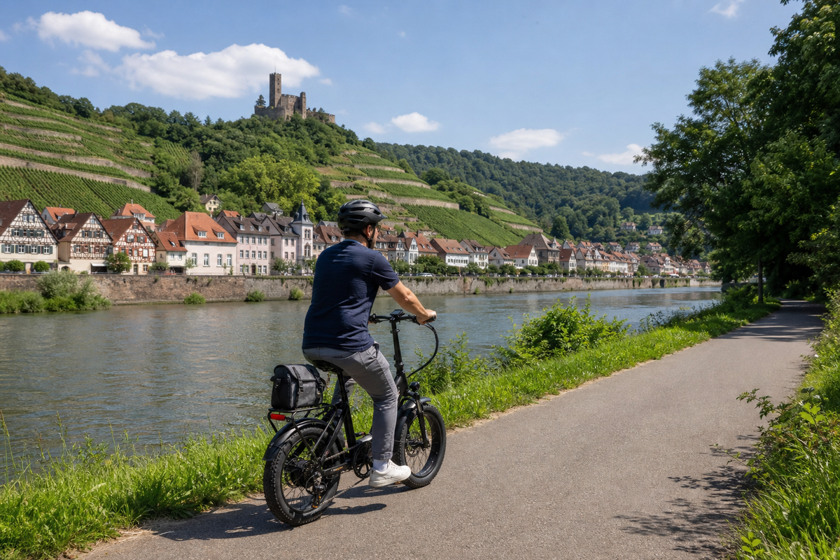
The Neckar Valley Cycle Path runs from the source of the Neckar near Villingen-Schwenningen to its confluence with the Rhine near Mannheim. The current digital track measures 374.79 kilometres. Eight official stages, numerous railway stations and a predominantly downhill profile make the route flexible—provided construction works, surfaces and long daily distances are planned for honestly.
How long is the Neckar Valley Cycle Path really?
Depending on the publication year and rounding, official pages list 370, 374 or 375 kilometres; an older data set even gives 362 kilometres. This travel plan uses the current digital tour of 374.79 kilometres as its reference. In everyday use, “around 375 kilometres” is sufficient. The actual bike computer reading changes with accommodation detours, city visits and diversions.
The eight published stage values also do not add up to exactly the same figure as the current overall track. This points to different track versions or connecting routes and is no reason to create false precision. The daily distances are planning values; navigation should use the official GPX file downloaded shortly before the trip.
The direction from the source to the river mouth makes use of the river’s overall descent. Nevertheless, according to the current data set, the route includes around 671 metres of climbing. “Downstream” therefore does not mean “without climbs.”
Eight official stages to Mannheim
The official division varies in difficulty. The short opening stage is classified as moderate, while the remaining stages are classified as easy. “Easy” describes the route profile, not necessarily a low daily workload: 52 to 63 kilometres with luggage still make for a full day of riding.
| Day | Stage | Distance | Classification and planning |
|---|---|---|---|
| 1 | Villingen-Schwenningen–Rottweil | 27.30 km | Moderate. A short but hilly opening stage from the source; do not underestimate it based on the number of kilometres. |
| 2 | Rottweil–Horb | 48.42 km | Easy. Clarify morning supplies and allow time for changing surfaces. |
| 3 | Horb–Tübingen | 35.46 km | Easy. A shorter day with plenty of reserve for Tübingen or a later train journey. |
| 4 | Tübingen–Esslingen | 52.63 km | Easy. Town crossings and the transition into the more densely populated Neckar region take time. |
| 5 | Esslingen–Besigheim | 59.52 km | Easy. Check the Stuttgart crossing and current S21 diversion; allow a generous buffer. |
| 6 | Besigheim–Bad Wimpfen | 38.53 km | Easy. A shorter section that is suitable as a rest day or detour reserve. |
| 7 | Bad Wimpfen–Eberbach | 43.34 km | Easy. Mark railway stations as exit points; check riverside paths during high water. |
| 8 | Eberbach–Mannheim | 62.60 km | Easy but long. Heidelberg and the optional ferry may increase the time required. |
For many touring cyclists, eight days is suitable. Those traveling with children or planning only 35 to 45 kilometers per day should split Tübingen–Esslingen, Esslingen–Besigheim, and Eberbach–Mannheim at a railway station. An additional city or rest day in Tübingen, Stuttgart, or Heidelberg prevents sightseeing from being squeezed into the longest riding days.
From the source through four distinct landscapes
The first part leads from the Schwenningen Marsh via Rottweil into the upper Neckar Valley. Between Horb and Tübingen, the valley widens before the route reaches the Stuttgart metropolitan area via Esslingen. North of there, wine-growing towns, bends in the Neckar, and historic cities alternate. From Bad Wimpfen onward, castles and wooded slopes characterize the river; Heidelberg and the Rhine Plain form the final section to Mannheim.
This sequence helps with planning overnight stays: In the more rural upper reaches, accommodation and opening hours should be arranged earlier, while in the cities, access and secure bicycle storage become more important. Accommodation near the center is not automatically easy to reach with a loaded bike.
Which section is suitable for a shorter trip?
There is no objectively “most beautiful section.” From Rottweil, the upper reaches, half-timbered towns, and Tübingen and Esslingen are the highlights. From Stuttgart, wine-growing towns and potential cultural stops in Marbach and Ludwigsburg follow; near Besigheim, the Hessigheim Rock Gardens are an additional viewpoint destination. Bad Wimpfen, Guttenberg Castle, and Heidelberg shape the lower reaches. Not all destinations lie directly on the track. For a short day, choose a focus and calculate its additional distance separately.
Even if you start in Rottweil or Stuttgart, load the complete official track and reset the starting point in the navigation. This preserves construction notices and the correct connecting route.
Surface, difficulty, and signage
The current tour data lists 55 percent asphalt, 30 percent fine gravel, 13 percent natural trail, and 2 percent other surfaces. The route is therefore largely suitable for touring bikes, but it is not fully paved. After rain, natural-surface and gravel sections may be slower, more slippery, or muddy. Sturdy tires with sufficient width are more suitable than a pure road-bike setup.
In both directions, the signage follows the FGSV system. The Neckar Valley Cycle Route logo is displayed at junctions and on destination signs; green direction arrows provide additional guidance in between. In Stuttgart, Heidelberg, and other areas with construction work, an older track may differ from the signposted detour. On-site signs and official instructions take precedence.
The first day is officially rated moderate, while all subsequent legs are rated easy. This classification says little about headwinds, heat, luggage, or a 62-kilometer leg. Realistic planning considers terrain and daily distance separately.
E-bike and family: choose suitable sections
A standard pedelec is well suited to the route. The portal lists charging stations and bicycle service businesses, but their accessibility and opening hours are checked for the travel date. A range reserve remains necessary for long days. The assistance level, luggage, wind, and frequent starts in urban traffic can significantly increase consumption. Bring the charger and battery key.
Many flat sections through the valleys are suitable for beginners and families. Nevertheless, the complete eight-day itinerary is not generally a children's route. Leg 1 has more varied terrain; Leg 5 passes through the Stuttgart metropolitan area; and Leg 8 is long at 62.6 kilometers. With younger children, these days should be split, and the traffic conditions along the selected section should be checked in advance.
Trailers, recumbent bikes, and particularly heavy e-bikes also require individual assessment. Narrow passages, temporary traffic lights, elevators, and a ferry ramp may be more decisive than the elevation gain. General suitability does not replace checking dimensions or verifying step-free station access.
Rail connections as a genuine Plan B structure
Rottweil, Horb, Tübingen, Reutlingen, Plochingen, Stuttgart, Heidelberg, and Mannheim are important rail hubs on or near the route. There are also numerous regional stations. This makes it possible to shorten a long leg or travel the route in sections. However, a station symbol does not automatically mean step-free access or guaranteed bicycle transport.
The official portal explicitly points out that Neckarsulm is only partially accessible. Heilbronn Central Station or Bad Friedrichshall may be more practical alternatives for heavy e-bikes. Before booking, the elevator status, platform access, bicycle ticket requirements, and train capacity are checked. Bags are removed before boarding so the bike can be moved more quickly.
When replacement bus services are operating, taking bicycles is often excluded or severely restricted. Therefore, the day plan should include a later regular train in addition to the preferred connection.
Ferry between Neckarhausen and Ladenburg
A ferry can be used as part of the route between Neckarhausen and Ladenburg. It is an option, not a mandatory or always available crossing. According to the operator, ferry service does not operate in fog, flooding, or thunderstorms. The timetable and status must be checked on the same day.
The railway bridge for bicycle and pedestrian traffic serves as an alternative. This option is marked in advance in the GPX file or local signage so that a sudden ferry cancellation does not lead to a frantic search along the riverbank.
Accommodation, supplies, and travel season
Rottweil, Horb, Tübingen, Esslingen, Besigheim, Bad Wimpfen, Eberbach, and Mannheim are the official stage towns. In larger cities, the selection is broader; in smaller towns, a secure bicycle storage area or an e-bike charging facility may be fully booked early. Requirements should be confirmed directly with the host.
Official package tours are offered from April 1 to October 31. This period is a useful guide for the cycling season, but no guarantee of weather, ferry service, or clear paths. Accommodations are booked early on holiday weekends and during major events. Each day’s planning includes water, emergency provisions, two possible stops, and a train exit point.
Construction and detours on September 3, 2026
The official notices page currently lists several relevant updates. Between Obernau and Bad Niedernau, construction traffic with traffic-light control and possible waiting times of up to around 20 minutes has been in place since April 2026. A detour is still listed for Heidelberg-Neuenheim. Between Stuttgart-Obertürkheim and Untertürkheim, a longer-term detour remains in place because of Stuttgart 21, presumably until 2027.
An older notice for Unterensingen was limited until July 24, 2026, and is therefore not listed as a current closure. For the other notices as well, an expected end date is not a guarantee that the route will reopen. The official route notices must be checked again 24 to 48 hours before departure. In cases of heavy rain or flooding, the Baden-Württemberg Flood Control Center should also be consulted.
Official map and GPX
The official digital full tour includes an interactive map, elevation profile, and the “GPX track” toggle. No permanently stable direct file link was provided. The track is therefore loaded via the current tour page shortly before the trip. The official stage pages supplement the daily details.
This article uses standard links and does not reproduce the interactive viewer, PDF map, logo, or GPX file. Individual content on the portal may be marked with CC BY-SA; a licence applies only to the specifically designated asset and with full attribution, source link, and licence link. Without such clear designation, nothing is reused.
Pre-departure checklist
- Download the current GPX from the official tour page and save it offline.
- Check Stuttgart, Heidelberg, and Obernau updates 24 to 48 hours in advance.
- Check the flood situation and the Neckarhausen ferry on the day of travel.
- Split long stages at a railway station for children or a more leisurely ride.
- Check the elevator, bicycle transport, and backup connection in advance.
- Confirm that the accommodation offers e-bike charging and secure bicycle storage.
Conclusion
The Neckartal Cycle Route connects the upper reaches of the river, the Stuttgart metropolitan area, wine-growing towns, and the Rhine Plain over approximately 375 kilometres. The eight official stages provide a possible basic plan, provided that “easy” is not confused with “short.” The current GPX, rail options, and ongoing detours are part of the planning; for families, long or traffic-complex days should be split.
Sources and current planning
- Neckartal Cycle Route: official full tour – current track, length, elevation profile, surface, and GPX access; checked on September 3, 2026.
- Official stage overview – eight sections, distances, and classifications.
- Current updates on the Neckartal Cycle Route – regularly updated construction sites and detours.
- Arrival and departure – rail hubs, bicycle transport, and station information.
- Bicycle services and charging stations – official service overview.
- Municipality of Edingen-Neckarhausen: Ferry – operation, reasons for cancellations, and alternative options.
- Baden-Württemberg Flood Forecasting Centre – current water-level and warning information.
- German River Routes: Neckartal Cycle Route – secondary overview of topics and stops; details cross-checked against the official portal.
Note: Distances and times are planning estimates. Current official authority, operator, and traffic updates take precedence.
Share:
Plan the entire Rhine Cycle Route: 1,450 km from Andermatt to the North Sea
Moselle Cycle Route in 10 stages: from Perl to Koblenz