

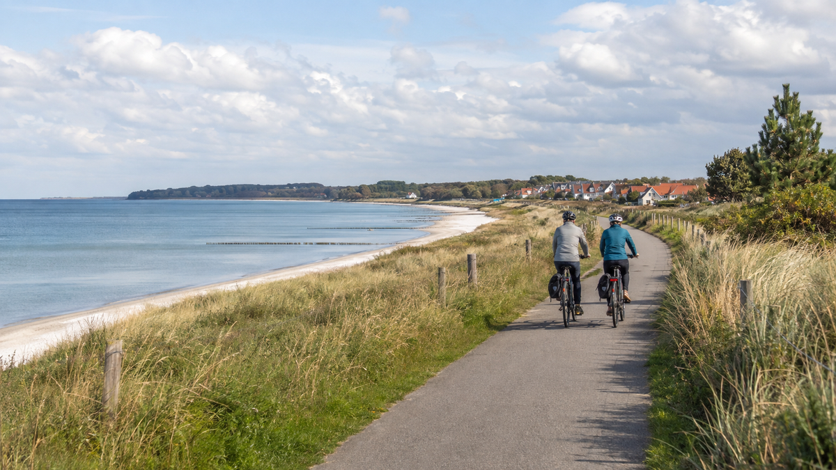
The German Baltic Sea Cycle Route is not a short beach ride. From Flensburg Fjord to Ahlbeck on Usedom, it connects D-Route 2 with EuroVelo 10 and comprises two major regional sections: Schleswig-Holstein states 438 kilometres to Travemünde, while Mecklenburg-Western Pomerania covers around 690 kilometres to Ahlbeck. Together, this gives a planning figure of approximately 1,128 kilometres. Current GPX tracks, island loops, and diversions may differ. The following 24-day plan stays close to the official stages and splits two very long island sections.
Baltic Sea Cycle Route at a glance
| Point | Planning figure |
|---|---|
| Length | approx. 1,128 km as the sum of the official regional figures of 438 km and 690 km |
| Start and finish | Flensburg/Flensburg Fjord to Ahlbeck on Usedom |
| Route | D-Route 2, also the German section of the Baltic Sea Cycle Route/EuroVelo 10 |
| Time required | 24 riding days here; an additional 2 to 3 buffer or rest days are recommended |
| Terrain profile | mostly flat to gently hilly, with more climbs on Rügen and Usedom; wind is an additional physical challenge |
| Ferries | Priwall, Warnemünde–Hohe Düne, and the Wittow Ferry, depending on the current track |
For Schleswig-Holstein, download the eleven official GPX stages, and for Mecklenburg-Western Pomerania, download the current complete track. The nationwide Germany Cycle Route Planner also provides the GPX track for D-Route 2. Choose one version of the track and do not inadvertently mix kilometres from different variants.

24 realistic stages from Flensburg to Ahlbeck
The figures for Schleswig-Holstein are rounded from the official stage GPX tracks; the figures for Mecklenburg-Western Pomerania are based on the official stage table. They are working figures for finding accommodation and planning daily distances, not a guarantee of the distance of a diversion.
| Day | Section | approx. km | Planning note |
|---|---|---|---|
| 1 | Flensburg–Glücksburg | 20 | short arrival day; test the track and luggage |
| 2 | Glücksburg–Gelting | 35 | Factor in coastal winds and small climbs |
| 3 | Gelting–Kappeln | 25 | deliberately short; allow time for shopping and a weather reserve |
| 4 | Kappeln–Eckernförde | 45 | Reassess the surface after rain |
| 5 | Eckernförde–Kiel | 47 | Check the city approach and possible construction sites |
| 6 | Kiel–Behrensdorf | 50 | Keep wind protection and an extra supply reserve readily available |
| 7 | Behrensdorf–Großenbrode | 51 | Confirm accommodation in advance during the season |
| 8 | Großenbrode–Puttgarden | 43 | first part of the Fehmarn loop |
| 9 | Puttgarden–Großenbrode | 46 | second island section; do not mistake it for a direct return journey |
| 10 | Großenbrode–Grömitz | 40 | Do not assume rail and bus replacements as a reliable bicycle backup |
| 11 | Grömitz–Travemünde | 49 | Check the ferry status for the next morning |
| 12 | Travemünde–Wismar | 55 | Coordinate the Priwall crossing with the selected D2 track |
| 13 | Wismar–Rerik | 60 | start early; do not plan provisions only at beach resorts |
| 14 | Rerik–Warnemünde | 40 | short day with time for weather conditions and cliff sections |
| 15 | Warnemünde–Zingst | 60 | Warnow Ferry plus a long coastal section |
| 16 | Zingst–Stralsund | 55 | Observe national park rules and current route notices |
| 17 | Stralsund–Schaprode | 70 | long island day; buy water and food early |
| 18 | Schaprode–Glowe | 50 | Confirm the Wittow Ferry and accommodation in Glowe before departure |
| 19 | Glowe–Sassnitz | 45 | shared section from the official 95-km island stage |
| 20 | Sassnitz–Putbus | 70 | Allow realistically for Rügen’s climbs and breaks |
| 21 | Putbus–Stralsund | 45 | Return to the mainland; be mindful of bridge winds |
| 22 | Stralsund–Greifswald | 35 | Regenerate before the final block |
| 23 | Greifswald–Wolgast | 50 | shared from the official 90-km final stage |
| 24 | Wolgast–Ahlbeck | 40 | Plan for island traffic and a safe arrival at your destination |
Plan three ferry crossings without improvisation
In Travemünde, the Priwall ferries connect the two banks of the Trave. The Norder Ferry is intended for pedestrians and bicycles, but may be canceled due to weather and does not operate at night. Farther south, the car ferry also carries bicycles. Use the connection that matches the current GPX, and check times and fares with the operator; the official Lübeck tourism website describes both options.
Between Warnemünde and Hohe Düne, include passenger and bicycle tickets in your planning. The RSAG lists a separate bicycle fare for this route. On Rügen, the Wittow Ferry connects the northern and southern parts of the island. The operator publishes seasonal timetables; for 2026, the website lists a period from May 12 to October 11. Check the current timetable for your travel year. In the event of a cancellation, you will need a considerably longer inland route.
Rail connections are a backup plan, not a guarantee
Flensburg, Eckernförde, Kiel, several towns in Lübeck Bay, Travemünde, Warnemünde, Stralsund, and Ahlbeck offer useful rail access points. Fehmarn is a special case: Because of the rail works, the Schleswig-Holstein portal refers to bus route X85 between Lübeck and Fehmarn and states that bicycle transport is limited. Do not plan a spontaneous interruption there with a fully loaded bicycle without confirming the specific connection first.
For long-distance services, you need a bicycle ticket and a space reservation. On regional services, there is no general guarantee that bicycles can be taken along, especially on summer weekends. Search DB with a bicycle, allow more time for transfers, and note alternative stations.
Best time to travel, wind, and accommodation
Schleswig-Holstein states that early March to the end of October is the best time to travel. For the complete route, May to September is usually easier because daylight, accommodation, and seasonal ferries align better. This is not a guarantee of good weather. Coastal winds can make 50 kilometers considerably longer; strong winds, thunderstorms, and heat justify reserving an extra day.
During the peak season, the regional route operator recommends booking early. In particular, do not wait until the afternoon to book Fehmarn, Fischland-Darß-Zingst, Rügen, and Usedom. Ask about secure bicycle storage, possible late arrival, and a genuinely usable charging facility. Bring cash, as the Schleswig-Holstein portal points out that some cafés and snack bars do not accept card payments.
Food and equipment
- replenish water and a proper emergency meal every morning for rural coastal sections
- pack a windbreaker, waterproof layer, sun protection, and a warm spare layer in a dry bag
- save official tracks, accommodation, ferry websites, and rail alternatives offline
- Service the brakes, tyres, chain, lights and luggage fittings before departure
- Take suitable puncture-repair materials, a pump, tools, a power bank and a first-aid kit
- Ride through nature reserves only on designated paths and respect local closures
Do not add rest days only once you are exhausted
Plan at least one buffer day after Fehmarn or Travemünde and another before or on Rügen. This lets you absorb strong winds, a cancelled ferry or a repair without having to make up several 80-kilometre days. A rest day does not have to be completely bike-free: use it for laundry, shopping, checking the brakes and tyres, and reorganising your bags. Also recheck the next two accommodations and all ferry websites. If you combine short stages, still keep an early destination as an exit option. Especially along the coast, a reasonable morning forecast can deteriorate over the course of the day.
Frequently asked questions
How long is the German Baltic Sea Cycle Route?
Approximately 1,128 kilometres as the sum of the current regional portal figures. Your GPX may differ due to variants and detours. Therefore, use a specific track rather than just the rounded total distance.
Are 24 days necessary?
No. Trained touring cyclists can combine short stages. However, the plan allows time for islands, ferries and wind and divides the official 95- and 90-kilometre sections.
Is the route completely flat?
No. Schleswig-Holstein mentions hilly sections, and Mecklenburg-Western Pomerania specifically points out climbs on Rügen and Usedom. Wind and short unpaved sections are additional factors.
Can I shorten the route by train at any time?
No. Bicycle spaces are limited; on Fehmarn, a bus temporarily replaces the train. A connection is only a reliable Plan B once bicycle transport, fares and space availability have been clarified.
Official planning: Baltic Sea Schleswig-Holstein, Discover Mecklenburg-Western Pomerania and D-Route 2 in the Germany cycle route planner.
Share:
Changing bicycle pedals: How to identify a left-hand thread safely
Kocher-Jagst Cycle Route in 6 Days: Circular Tour Starting in Aalen